File:Cyprus 1973 ethnic neutral.svg

此SVG文件的PNG预览的大小:800 × 570像素。 其他分辨率:320 × 228像素 | 640 × 456像素 | 1,024 × 729像素 | 1,280 × 912像素 | 2,560 × 1,824像素 | 1,088 × 775像素。
原始文件 (SVG文件,尺寸为1,088 × 775像素,文件大小:76 KB)
摘要

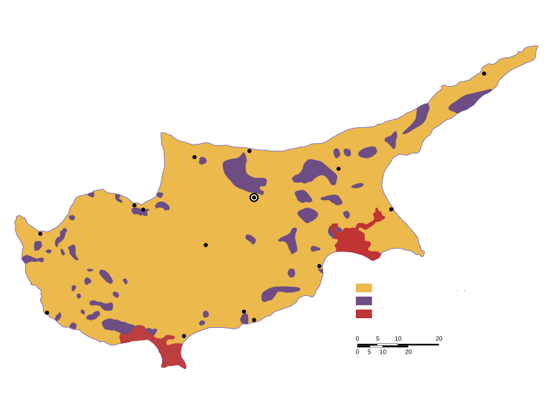
| 描述 | Ethnic distribution svg map of Cyprus in 1973, language neutral (check the source for town names and legend). |
| 日期 | |
| 来源 | Drawn by a map from the "Issues of the Middle East", CIA publication, at the Perry Castaneda colletion, Link: [1]. The yellow colour shows land with predominantly greek-cypriot population, while purple shows predominantly turkish-cypriot population (known in greece as "turkish-cypriot pockets"). British military bases are displayed in red colour. |
| 作者 | Badseed |
| 授权 (二次使用本文件) |
Public Domain |
| 其他版本 |
|


![[1]](http://www.lib.utexas.edu/maps/europe/cyprus_ethnic_1973.jpg)
许可协议
| 我,本作品著作权人,释出本作品至公有领域。这适用于全世界。 在一些国家这可能不合法;如果是这样的话,那么: 我无条件地授予任何人以任何目的使用本作品的权利,除非这些条件是法律规定所必需的。 |
文件历史
点击某个日期/时间查看对应时刻的文件。
| 日期/时间 | 缩略图 | 大小 | 用户 | 备注 | |
|---|---|---|---|---|---|
| 当前 | 2007年2月6日 (二) 20:31 | | 1,088 × 775(76 KB) | Badseed | {{Information |Description=Ethnic distribution map of Cyprus in 1973. Labels in Greek. |Source=Drawn by a map from the "Issues of the Middle East", CIA publication, at the Perry Castaneda colletion, Link: [http://www.lib.utexas.edu/maps/europe/cyprus_eth |
文件用途
以下页面使用本文件:
全域文件用途
以下其他wiki使用此文件:
- am.wikipedia.org上的用途
- ar.wikipedia.org上的用途
- azb.wikipedia.org上的用途
- az.wikipedia.org上的用途
- be.wikipedia.org上的用途
- bg.wikipedia.org上的用途
- ca.wikipedia.org上的用途
- cs.wikipedia.org上的用途
- en.wikipedia.org上的用途
- eo.wikipedia.org上的用途
- es.wikipedia.org上的用途
- et.wikipedia.org上的用途
- eu.wikipedia.org上的用途
- fa.wikipedia.org上的用途
- fi.wikipedia.org上的用途
- gl.wikipedia.org上的用途
- hu.wikipedia.org上的用途
- id.wikipedia.org上的用途
- it.wikipedia.org上的用途
- ja.wikipedia.org上的用途
- ka.wikipedia.org上的用途
- lv.wikipedia.org上的用途
- nl.wikipedia.org上的用途
- no.wikipedia.org上的用途
- pnb.wikipedia.org上的用途
- pt.wikipedia.org上的用途
- ru.wikipedia.org上的用途
- sr.wikipedia.org上的用途
- sv.wikipedia.org上的用途
- th.wikipedia.org上的用途
- tr.wikipedia.org上的用途
- tt.wikipedia.org上的用途
- ur.wikipedia.org上的用途
- uz.wikipedia.org上的用途
- vi.wikipedia.org上的用途
- www.wikidata.org上的用途