File:Charleston Harbor 1861.png

本预览的尺寸:768 × 599像素。 其他分辨率:308 × 240像素 | 615 × 480像素 | 984 × 768像素 | 1,280 × 999像素 | 1,693 × 1,321像素。
原始文件 (1,693 × 1,321像素,文件大小:400 KB,MIME类型:image/png)
| 描述 |
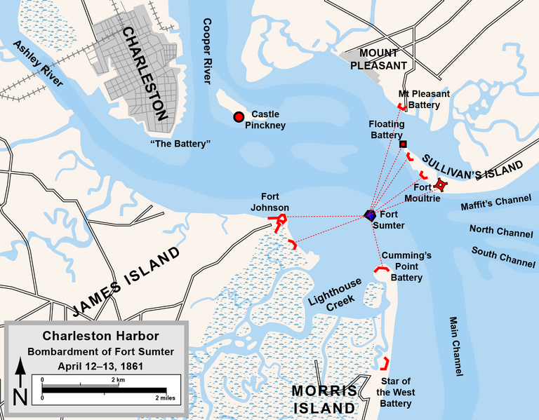
English: Map of the harbor of Charleston, South Carolina, showing Confederate forts and the bombardment of Fort Sumter, April 1861. Drawn in Adobe Illustrator CS5 by Hal Jespersen. Graphic source file is available at http://www.posix.com/CWmaps/
本文件采用知识共享署名 3.0 未本地化版本许可协议授权。 署名: Map by Hal Jespersen, www.posix.com/CW
|
| 日期 | |
| 来源 | 自己的作品 |
| 作者 | Hlj |
文件历史
点击某个日期/时间查看对应时刻的文件。
| 日期/时间 | 缩略图 | 大小 | 用户 | 备注 | |
|---|---|---|---|---|---|
| 当前 | 2024年3月9日 (六) 19:59 | | 1,693 × 1,321(400 KB) | Hlj | Reverted to version as of 18:43, 13 March 2011 (UTC) |
| 2023年8月5日 (六) 16:09 |  | 998 × 777(600 KB) | Cosma Seini | Italian version | |
| 2011年3月13日 (日) 18:43 |  | 1,693 × 1,321(400 KB) | Hlj | Converting to a new watercolor palette and different road network. | |
| 2011年1月11日 (二) 22:21 |  | 1,693 × 1,321(365 KB) | Hlj | {{Information |Description={{en|1=Map of the harbor of Charleston, South Carolina, showing Confederate forts and the bombardment of Fort Sumter, April 1861. Drawn in Adobe Illustrator CS5 by Hal Jespersen. Graphic source file is available at http://www.po |
文件用途
以下页面使用本文件:
全域文件用途
以下其他wiki使用此文件:
- de.wikipedia.org上的用途
- en.wikipedia.org上的用途
- hu.wikipedia.org上的用途
- it.wikipedia.org上的用途
- krc.wikipedia.org上的用途