File:Backa.png

本预览的尺寸:560 × 599像素。 其他分辨率:224 × 240像素 | 449 × 480像素 | 918 × 982像素。
原始文件 (918 × 982像素,文件大小:55 KB,MIME类型:image/png)
摘要
| 描述 |
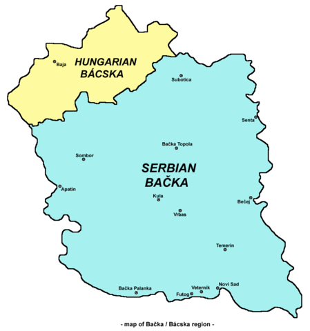
English: Map of en:Bačka region
Српски / srpski: Мапа Бачке |
| 日期 | 2006年5月22日 (原始上传日期) |
| 来源 | 本檔案是從en.wikipedia轉移到維基共享資源。 |
| 作者 | Original uploader and author was PANONIAN at en.wikipedia |
| 其他版本 |
|
.png)

许可协议
self made map by user:PANONIAN
| 本作品已被作者英语维基百科的PANONIAN释出到公有领域。这适用于全世界。 在一些国家这可能不合法;如果是这样的话,那么: PANONIAN无条件地授予任何人以任何目的使用本作品的权利,除非这些条件是法律规定所必需的。 |
References
References for historical/geographical borders of Bačka and modern state borders:
- Školski istorijski atlas, Zavod za izdavanje udžbenika Socijalističke Republike Srbije, Beograd, 1970.
- Milovan Radovanović, Kosovo i Metohija - antropogeografske, istorijskogeografske, demografske i geopolitičke osnove, Beograd, 2008.
- Slobodan Radovanović, Geografski atlas, Magic Map, Smederevska Palanka, 2001.
- Školski geografski atlas, Intersistem Kartografija, Beograd, 2004.
- Denis Šehić - Demir Šehić, Geografski atlas Srbije, Beograd, 2007.
References for sizable cities and towns:
- Popis stanovništva, domaćinstava i stanova u 2002., Stanovništvo, nacionalna ili etnička pripadnost - Podaci po naseljima, knjiga 1, Republika Srbija - Republički zavod za statistiku, Beograd, februar 2003.
- http://world-gazetteer.com/ archive copy at the Wayback Machine
原始上传日志
原始描述頁面位於這裡。下列使用者名稱均來自en.wikipedia。
- 2006-05-22 13:18 PANONIAN 560×625×8 (26578 bytes)
文件历史
点击某个日期/时间查看对应时刻的文件。
| 日期/时间 | 缩略图 | 大小 | 用户 | 备注 | |
|---|---|---|---|---|---|
| 当前 | 2009年9月17日 (四) 12:35 | | 918 × 982(55 KB) | PANONIAN | Reverted to version as of 13:56, 16 September 2009 - trying to fix thumbnail problem |
| 2009年9月17日 (四) 12:34 |  | 560 × 625(26 KB) | PANONIAN | Reverted to version as of 21:18, 16 September 2009 - trying to fix thumbnail problem | |
| 2009年9月16日 (三) 21:18 |  | 918 × 982(55 KB) | PANONIAN | Reverted to version as of 13:56, 16 September 2009 - fixing thumbnail problem | |
| 2009年9月16日 (三) 21:18 |  | 560 × 625(26 KB) | PANONIAN | Reverted to version as of 00:47, 16 March 2007 - fixing thumbnail problem | |
| 2009年9月16日 (三) 13:56 |  | 918 × 982(55 KB) | PANONIAN | ||
| 2007年3月16日 (五) 00:47 |  | 560 × 625(26 KB) | Frokor | {{Information |Description=Map of en:Bačka region (self made) en:Category:Maps of Vojvodina en:Category:Maps of Serbia en:Category:Maps of Hungary |Source=Originally from [http://en.wikipedia.org en.wikipedia]; description page is/wa |
文件用途
以下页面使用本文件:
全域文件用途
以下其他wiki使用此文件:
- az.wikipedia.org上的用途
- cs.wikipedia.org上的用途
- de.wikipedia.org上的用途
- de.wiktionary.org上的用途
- en.wikipedia.org上的用途
- es.wikipedia.org上的用途
- fr.wikipedia.org上的用途
- gl.wikipedia.org上的用途
- hr.wikipedia.org上的用途
- id.wikipedia.org上的用途
- it.wikipedia.org上的用途
- ja.wikipedia.org上的用途
- ko.wikipedia.org上的用途
- mk.wikipedia.org上的用途
- nl.wikipedia.org上的用途
- nn.wikipedia.org上的用途
- no.wikipedia.org上的用途
- pl.wikipedia.org上的用途
- pl.wiktionary.org上的用途
- ro.wikipedia.org上的用途
- rue.wikipedia.org上的用途
- sh.wikipedia.org上的用途
- sk.wikipedia.org上的用途